
Fencing and fence repairs in Westbury-on-Trym
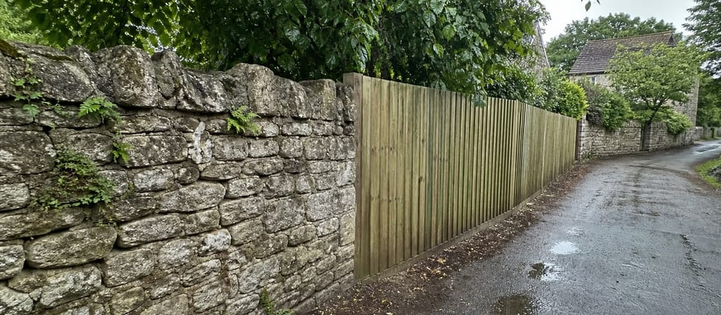
Westbury-on-Trym is one of Bristol's oldest conservation areas, and its limestone rubble walls are specifically protected in the council's own conservation plan. That makes it the one place in the city where the wrong boundary decision is a planning matter, not a taste matter.
About Westbury-on-Trym
Conservation Area No.2, designated in 1972, one of the first Bristol drew. The stock runs from Georgian and Regency villas on Westbury Hill to Victorian cottages in the Waters Lane triangle, which the council's appraisal describes as a typical herringbone pattern with very narrow residential streets. Narrow streets and tight plots mean a lot of what we do here arrives by barrow, and a lot of it is a repair to an existing structure rather than a new run.
What you are allowed to put up in Westbury-on-Trym
Two things to know before anyone quotes you. First, this is a conservation area, so the council takes an interest in what a boundary looks like from the street even where permitted development would otherwise allow it. Second, and this is the one nobody mentions, Bristol City Council's conservation plan for Westbury-on-Trym carries principle P35, which specifically protects the many limestone rubble walls in the village and flags their erosion and their removal for parking as a problem. If your boundary is one of those walls, taking it out to widen an entrance is not a job you want to start without asking. Westbury-on-Trym itself carries no Article 4 Direction, but the neighbouring Henleaze Article 4, in force since 22 April 2021, does require permission to demolish a gate, fence, wall or any other means of enclosure. Those two areas sit close together in BS9, so we check the address rather than the postcode.
The boundaries round here
Limestone rubble walls, old and worth keeping, alongside later timber. Where a wall is bulging or losing its cap, the honest answer is usually a repair by someone who works in stone, not a fence in front of it. Where timber is the right answer, we keep it clear of the wall and we do not use the wall as a post. Anything we take down inside the conservation area, we photograph first.
Wind, ground and what actually fails
The village sits on the valley floor along Trym Road and rises to steep escarpments at Channels Hill, with council map spot heights recorded at 32 and 33 metres. The council's own appraisal notes that hilltop features here are particularly vulnerable, and the same is true of a boundary: the run at the top of the slope takes the weather that the run at the bottom never sees. Wet valley ground at one end of a street and exposed high ground at the other is a good argument for pricing the two halves of a boundary differently.
Westbury-on-Trym postcodes we cover
BS9, BS10.
Which council covers Westbury-on-Trym
Westbury-on-Trym is Bristol City Council ground, and that is the authority whose rules we work to on your address. It matters more here than most people expect: our patch straddles a council boundary, so a rule that applies on one street can have no force at all a mile away. We check the right authority's conservation area map and its Article 4 Directions against your postcode before we price anything, and we tell you what we found. The full picture is in our guide to fence height and planning permission in Bristol.
What we do in Westbury-on-Trym
- Boundary checked before we quote Whose fence it is, and what the council allows on that street, settled first.
- Fixed written quotes Measured length, height, materials, waste and price on one sheet.
- No cold calling, ever We never knock doors after a storm and we never leaflet a price.
- Insured installers Public liability cover on every job. Ask and we send the certificate.
Get a price in Westbury-on-Trym
Free visit, a proper measure, the boundary checked, then a fixed price in writing.